Live · Trail · Salto, Uruguay
A trail for Salto. From the port to the quarry.
Salto has a river, a lake, native woodland and hot springs, but no signposted trail to walk. This is my proposal: 36 km along the Uruguay River and the Salto Grande lake, from the port to El Terrible quarry, to walk in stages or to cycle in a day. I have not walked it yet. Over the coming months I will report how it goes.
The essentials
- Distance35.8 km
- Stages3
- Terrainall flat
- On foot, the whole trailabout 9 h
- By bike, there and back69 km
- Statusproposal
October 2026 proposal · not yet walked
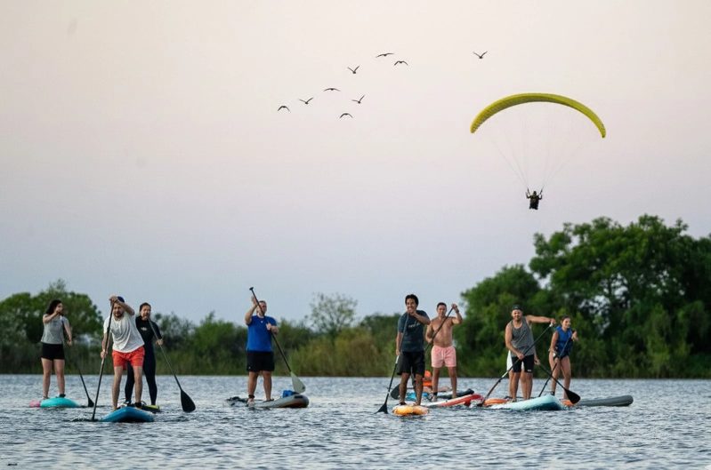
Paragliding and paddleboards on the Salto Grande lake · photo: Marcelo Cattani
01 · The idea
A year-round tourist city without a trail
The idea comes from something missing: Salto has no signposted trail at all. Yet the city sits on the Uruguay River, the Salto Grande lake is a few kilometres away and there is plenty of native woodland along the banks.
Salto sells itself as a tourist city all year round, and that is what this proposal is for: something that locals and visitors can enjoy in any season.
I was looking for a route on paths and tracks that already exist, with good scenery and native trees, and safe for locals and visitors. The northern shore, from the port to the lake, had all of that.
My first rough estimate was about 25 km from the port to the quarry. Once I drew it on the map, following the shore and every headland on the lake, it came to almost 36 km. Rather than cut it down, I split it into stages: anyone can walk one stretch, and whoever wants to can do the whole thing.
02 · The route
36 km in three stages
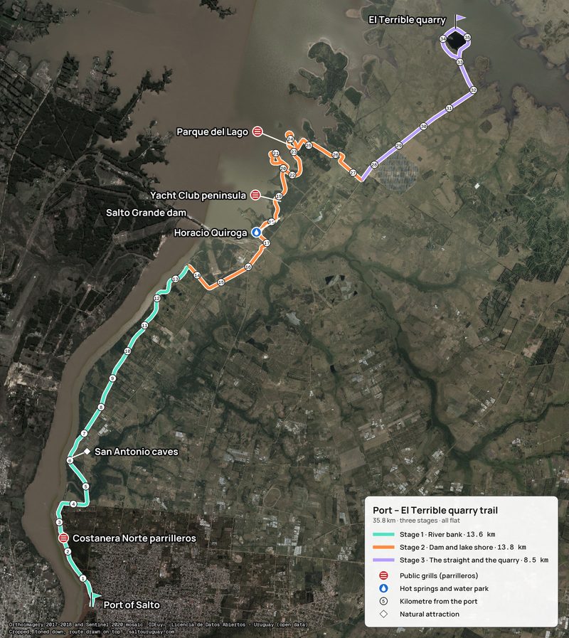
It is 35.8 km, all flat: it starts at the port, follows the river bank to the dam, runs along the lake shore and ends with a 2.7 km loop around El Terrible quarry.
| Stage | Stretch | Distance | On foot (4 km/h) |
|---|---|---|---|
| 1 · River bank | Port → dam area | 13.6 km | 3 h 25 min |
| 2 · Dam and lake shore | Dam area → the straight heading north-east | 13.8 km | 3 h 25 min |
| 3 · The straight and the quarry | The straight → El Terrible quarry, with the loop | 8.5 km | 2 h 05 min |
Each stage starts and ends somewhere you can reach by car, so nobody has to walk back the way they came. Those points still have to be confirmed on the ground.
03 · On the way
What is along the way
The trail passes some of the loveliest spots on Salto's shoreline, and it has three areas of public brick grills (parrilleros) for an asado.
| Km | Place | What is there |
|---|---|---|
| 2.5 | Costanera Norte parrilleros | Public grills on the northern riverside promenade, open 24 hours |
| 6.0 | San Antonio caves | Caves in the river bluff, right beside the trail |
| 13.6 | Salto Grande dam area | The trail leaves the river and skirts the dam area on roads |
| 18.2 | Hotel Horacio Quiroga and its water park | Hot-spring pools all year and a restaurant that does asado |
| 18.9 | Peninsula opposite the Yacht Club | A few grills with a table and toilets, 7:00 to 19:00 |
| 23.1 | Parque del Lago, council section | Grills, tables, toilets, a playground and a beach with lifeguards in season, 8:00 to 20:00 |
| 33.1 | El Terrible quarry | End of the route, with a 2.7 km loop around the quarryIt is a private diving centre |
The water park at the Horacio Quiroga takes day visitors, not just hotel guests: it is open every day from 10:00 to 18:00 and you pay at the gate (Intendencia de Salto, October 2026). Park hours can change with the season.
04 · On foot or by bike
In stages on foot, or all of it by bike
On foot, the best plan is to do it in stages: each one is a morning or an afternoon of walking. The whole trail is about 9 hours of walking, not counting stops.
By bike it can be done there and back in a day: 69 flat km, about 5 to 6 hours of riding. Along the shore there are stretches of narrow path, grass or sand, so some parts may have to be walked. Coming back by the road instead of the lake shore brings the total down to about 63 km.
A full day on the bike could look like this: an early start towards the quarry, back to Parque del Lago for an asado at midday, the afternoon at the Horacio Quiroga and the port again before the sun goes down.
- Bike: a mountain bike or a gravel bike, not a road bike.
- Water: 2 or 3 litres; there is almost no shade on the straight to the quarry.
- Summer: an early start.
- Fire: only in the parrilleros.
05 · Signage
Wooden signs with a QR code
I propose marking it with wooden signs, each with a QR code that opens the map, the distances and the places near that stretch.
- Four information panels: at the port, at each change of stage and at the quarry.
- Eight direction signs: at the junctions and turns where someone might hesitate.
- 35 kilometre markers: one per kilometre, with the distance from the port.
That way, at any point on the trail you know how far is left and where to get off it.
06 · What comes next
What is missing before it is a real trail
For now this is a proposal, not an open trail. Several stretches cross private land and cannot be walked without the owners' permission.
Before any signs go up, the route has to be walked and a few things confirmed:
- That the stretches off the public road have the owners' permission.
- Vehicle access at each change of stage.
- Whether the straight to the quarry is a local road or a main road with traffic.
- Whether the north side of the quarry loop floods when the lake is high.
Over the coming months I will publish updates on the route: photos, notes on each stretch and, depending on what I find when I walk it, changes to the line or confirmation that it works as it is.
My plan is to present it to the tourism office of the Intendencia de Salto, the city hall, together with other trail proposals.
Questions
What people ask about the trail
- Can the trail be walked yet?
- Not yet. It is a proposal: it is not signposted and several stretches cross private land. It has to be walked first, and the permissions obtained.
- How long is the trail and how long does it take?
- 35.8 km, all flat, in three stages of 13.6, 13.8 and 8.5 km. The whole thing is about 9 hours of walking, not counting stops; each stage takes between 2 and 3.5 hours.
- Can it be done by bike?
- Yes. There and back is 69 flat km, about 5 to 6 hours of riding on a mountain bike or a gravel bike. Along the shore there are stretches of narrow path, grass or sand.
- Where can you have an asado on the way?
- At the public parrilleros on the Costanera Norte (km 2.5), on the peninsula opposite the Yacht Club (km 18.9) and in the council section of Parque del Lago (km 23.1). Fires only in the parrilleros.
- How will it be signposted?
- With wooden signs carrying a QR code: four information panels, eight direction signs and 35 kilometre markers, one per kilometre.
Sources: distances measured on the proposed line. Intendencia de Salto · Destino Salto: Horacio Quiroga water park, day visitors (October 2026) · Vía Termal · Parque del Lago · Infoturismo19 · water parks in Salto · Google Maps · Parque del Lago, council section · Google Maps · peninsula opposite the Yacht Club · Google Maps · Costanera Norte parrilleros · Google Maps · San Antonio caves · Google Maps · El Terrible quarry. Updated: October 2026.
Do you know the shore?
What is the path like?
If you have walked any stretch, own land on the shore or want to help put up the signs, I would like to hear from you.